Lightstone, Property and Automotive Data and Solutions
In acknowledgment of World Disaster Reduction Day on the 13th of October, leading data analytics company, Lightstone, looked at data that can help mitigate risk in the financial sector. The focus of this data was on fire and flooding risks in specific areas and provinces from 2002 to 2020.
Fires
The fires in Cape Town in April of this year were estimated to have cost insurers around R1 billion. The Knysna fires of 2017 were averaged at more than triple that amount sitting at approximately R3.3 billion. What if some of the risk could be calculated ahead of time based on accurate historical data and insights?
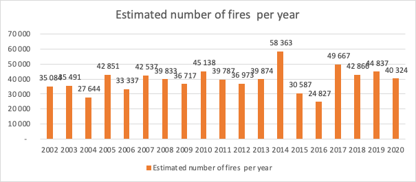
Over the 18 years of satellite imagery that Lightstone has analysed, 2014 showed the highest number of fires at 58 363 followed by 2017 with 49 667 fires.
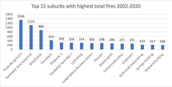
The top 3 suburbs that presented the highest number of fires over the period analysed are Rustenburg Ext 9, Vanderbijl Park Industrial and Meydustria in the south of Gauteng, with 1344, 1114 and 886 average fires respectively. “Having access to this type of risk data will prove invaluable to businesses, especially in the banking and insurance sectors, when developing products for clients,” says Mike Lehabe, Head of Financial Services for Lightstone.
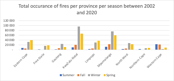
Lehabe observes, “When looking at the total number of fires per province per season, KwaZulu Natal’s winter season presents the highest number of average fires over the 18-year period at 95 410, followed by Mpumalanga’s winter season fires at 75 437.” For the Eastern Cape and Mpumalanga, spring present higher risk of fires in comparison to other seasons.
Floods
The Kwa-Zulu Natal floods that swept across the southern region of the province in 2019 were estimated to have cost R658 million in repairs to damaged roads and infrastructure. Could informed policy wordings and property insurance cover help owners in high-risk areas to adequately insure their assets?
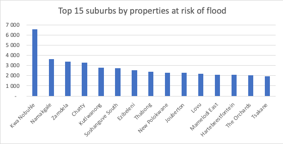
When Lightstone looked at flooding data for the same 18 year period, KwaNobuhle – a large informal settlement on the outskirts of Uitenhage in the Eastern Cape – was identified as the highest flood risk area.
“We based this data on each area’s proximity to the closest body of water, and what its elevation is over that body of water. We then counted all the properties per suburb, where the area was lower than its nearest body of water, and the distance to that body of water was less than 500m. This then highlights those areas that would be at the highest risk of flooding should their body of water get too much rain,” explains Lehabe.
In an uncertain world, being able to manage business risk based on accurate data becomes fundamental to a business’ sustainability and growth strategy. “If this wasn’t obvious before, the past 18 months has highlighted the necessity to understand complex data to be able to manage risk effectively.
This is prevalent now more than ever in a world populated with unpredictability,” Lehabe concludes.


